Combined data extracts
Spire Maritime AIS data extracts are normally provided in CSV format with data fields as listed in the table of data fields below. In the combined data extract format, Spire Maritime have processed the AIS messages per MMSI and joined together the most recently reported Static values with each new position message. This provides a per vessel view of AIS history based on the MMSI number.
Different AIS messages
AIS History data for vessels contains data from two different types of AIS messages: position messages and static voyage messages:
- Message Types 1, 2, 3, 18, 19, 27 are some common position messages that contain values in the position related fields, such as speed, heading, rate of turn, position, and status of vessels.
- Message Types 5 & 24 are static voyage messages and contain values in the static details and voyage related fields, such as identity, type, size and voyage information.
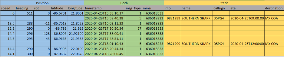
In this format we process the AIS messages per MMSI and join together the most recently reported Static values with each new position message, using the MMSI number as the join between them. For example – to identify the name, imo number, or type of ships related to the AIS Position reports, the mmsi number must be used to join together the 2 different sets of AIS data. So if position reports are recorded against MMSI 636018333 in AIS message type 1, then the imo and name of that vessel is discovered by looking for AIS message type 5 reported using the same MMSI number as shown below:
More information on AIS Message Types can be found in the Spire Maritime’s AIS Fundamentals article on AIS Message Types.
Data columns description
created_atdatetime- ISO 8601 formatted timestamp in UTC of the time the vessel record was merged to create combined information
timestampdatetime- ISO 8601 formatted timestamp in UTC of the time the AIS message was transmitted
static_updated_atdatetime- ISO 8601 formatted timestamp in UTC of the time the last AIS static message was received
position_updated_atdatetime- ISO 8601 formatted timestamp in UTC of the time the last AIS position message was received
mmsiinteger- The Maritime Mobile Service Identity of the vessel transmitting the AIS message
- Possible values:
000000000–999999999 latitudefloat- Vessel latitude in degrees (North=positive, South=negative)
- Range:
-90to+90 longitudefloat- Vessel longitude in degrees (East = positive, West=negative)
- Range:
-180to+180 speednumber- Vessel speed over ground represented in knots
- Possible values:
0 - 102.2knots,102.3(not available) coursenumber- Vessel course over ground in degrees
- Possible values:
0 - 359.9degrees,360.0(not available) headingnumber- Vessel true heading in degrees
- Possible values:
0 - 359degrees,511(not available) imointeger- IMO number of the ship
- Unique International Maritime Organization number for the vessel that stays with the ship for it’s life
- Valid values: 7 digit number
namestring- Vessel name
call_signstring- Vessel call sign
flagstring- Vessel flag
draughtfloat- Vessel draught represented in 1/10 meters
- Possible values:
0.1–255,0(not available; default) ship_and_cargo_typeinteger- Vessel ship and cargo type code
- Some common values:
30(fishing vessel),52(tug boat),70(cargo/fishing ship) (read our AIS Essentials article on determining a ship type) lengthnumber- Vessel length extracted from ship dimensions
to_bowandto_sternin meters widthnumber- Vessel width extracted from ship dimensions
to_portandto_starboardin meters etastring- Vessel estimated time of arrival as entered by the captain, represented in ISO 8601 format
- Possible values: Month:
1–12,0(not available; default); Day:1–31,0(not available; default); Hour:0–23,24(not available; default); Minute:0–59,60(not available; default) destinationstring- Vessel destination as entered by the vessel captain
statusstring- Vessel navigation status
- Some common values:
0(under way using engine),1(at anchor),3(restricted maneuverability),7(engaged in fishing),15(read the AIS essentials article on navigational status for more information) maneuverinteger- Vessel maneuver code
- Valid values:
0(not available; default),1(not engaged in special maneuver),2(engaged in special maneuver) accuracyinteger- Vessel GPS geo location accuracy in meters
- Possible values:
1(high, <=10 meters);0(low, >10 meters, default) rot- Vessel rate of turn
- Possible values:
-127 - 127;-128(not available) collection_typestring- How the message was captured
- Possible values: satellite or terrestrial or dynamic